ALC - Technics

Posts about:

Technical

Changes to Ordnance Survey global navigation satellite system control networks and geoid models for Great Britain, Ireland and Northern Ireland

The Ordnance Survey of Great Britain (OSGB), Ireland (OSI) and Northern Ireland (OSNI) have been working together to improve the OSGM02 geoid model resulting in OSGM15. OSGB has also updated the horizontal transformation OSTN02 to create OSTN15. The horizontal transformation for Ireland and Northern Ireland is unchanged.

Read More

Technics test new GPR technology

The Technics team can’t help but get excited when new surveying technology comes onto the market; with every new piece of equipment is the opportunity to work more efficiently and effectively to the benefit of our clients. Once we heard IDS had redesigned their Duo Ground Penetrating Radar system we immediately arranged for a demonstration with Drilline Products.

Read More

The Use Of BIM In Dispute Resolution

In the September edition of Civil Engineering Surveyor magazine Alasdair Snadden wrote an article looking at how Building Information Modeling (BIM) can be used in the dispute resolution process. This got us thinking about how surveying could be used to assist in dispute resolution and particularly in the creation of a Building Model. Typically, surveying is undertaken in the early stages of a project and involves the creation of Topographic and Measured Building Surveys. Surveyors are then utilised to set out procedures, and in some cases in the production of built external and internal drawings, towards the later stages.

Read More

The Importance of Utility Mapping

What is Utility Mapping?

A utility map shows the positioning and identification of buried pipes and cables beneath the ground. The procedure involves detecting things like sewers, electric cables, telecoms cables, gas and water mains. Combine this mapping process with a topographical survey and the results will provide you with a comprehensive detailed map of anything that is hidden underground or directly related to any above ground features. 


Example of a utility map.


Read More

BIM: What’s in it for Survey?

Geomatics World recently interviewed Derry Long on the subject of BIM

BIM is used most productively when it is applied to new building projects and, with the help of government, it has been pushed hard by the design software companies. Everything is new, from foundations upwards. Land surveyors are involved in surveying the site to show the area of land available and its relationship to existing structures and infrastructure and then, during construction, they may be hired to do setting out-work. Beyond that, their involvement is usually minimal and fragmented. However, there is the opportunity to be involved during the whole project life-cycle in providing as-built data, independent Industry QA and also providing a “basic” BI Modelling capability, to ease workflow. Since on-going and timely accurate and appropriate data is key to any fast-paced project there is also a role for surveyors to consult with the industry on the best methods and options for providing such data.

Read More

Technics Group attend the #RICSBIM Annual Conference 2013

Martin Penney – Technics Group Survey Director recently attended the Royal Institution of Chartered Surveyors (RICS for their annual BIM Conference.

The annual RICS BIM conference was very well attended in London last week by a wide cross-section of the industry including Government, academia, architectural practices, QS, facilities management and legal; Geomatics was the only under-represented sector as usual:

  • David Philip (Head of BIM Implementation, Cabinet Office)
  • Steve Race (BIM Ambassador, CIC)
  • Deborah Rowland (Head of Facilities Management, Cabinet Office)
  • Dirk Krolikowski (Associate/Architect at Rogers Stirk, Harbour + Partners)
  • Nick Nisbet (Director, AEC3 UK Ltd)
  • Dale Sinclair (Director, Dyer & Chairmain of RIBA Plan of Work Review Group)
  • Paul Fletcher (Co-founder Director, Through Architecture)
  • Professor David Greenwood (BIM Academy and Northumbria University)
  • Adrian Malone (Director, Faithful+Gould)
  • Michael Conroy Harris (Principal Legal Manager, Eversheds)
Read More

Martin Penney represents TSA at recent English Heritage BIM Conference

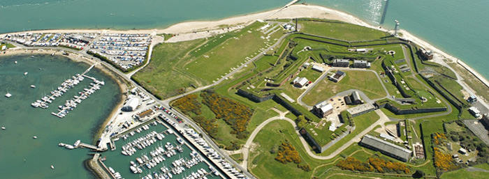
Fort Cumberland situated on Eastney Point at the entrance to Langstone Harbour on the Hampshire Coast was the impressive venue for English Heritage’s BIM Strategy Seminar in January.

The current remaining pentagonal fortification dates back to an early earthwork battery of 1716 and was the brainchild of William Duke of Cumberland- erstwhile of the Jacobite Rebellion and the Battle of Culloden. Built to control the entrance to Langstone Harbour with its impressive arsenal of 34 interlocking-arc guns, this strategic position also helped to defend the access to Portsmouth Harbour and its docks to the West.

Fort Cumberland. Photograph courtesy of English Heritage

Read More